Locus GIS brings a built-in NTRIP client and tools for higher accuracy mapping
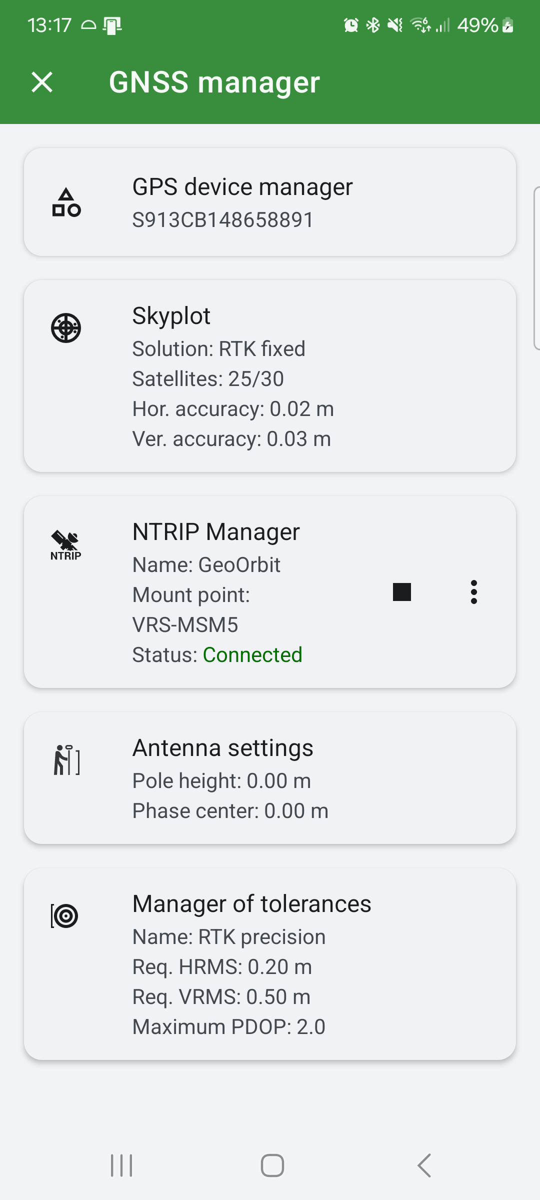
We are pleased to announce the latest version of our LocusGIS application, which includes a number of useful features for users who require high precision work. The new application offers the NTRIP client, which allows users to set tolerances (warning in case of insufficient accuracy) and also set the height of the datum. All important parameters related to GNSS setup can be found in the new GNSS manager.
NTRIP Client
NTRIP (Networked Transport of RTCM via Internet Protocol) is a protocol for the transmission of real-time GNSS corrections over the Internet. The NTRIP client enables the reception and implementation of this data in GNSS receivers, thereby significantly enhancing positional precision. The type of device in question will determine the level of accuracy achievable with the corrections in question, with centimeter accuracy in position and height being a possibility.
How does the NTRIP client work in LocusGIS?
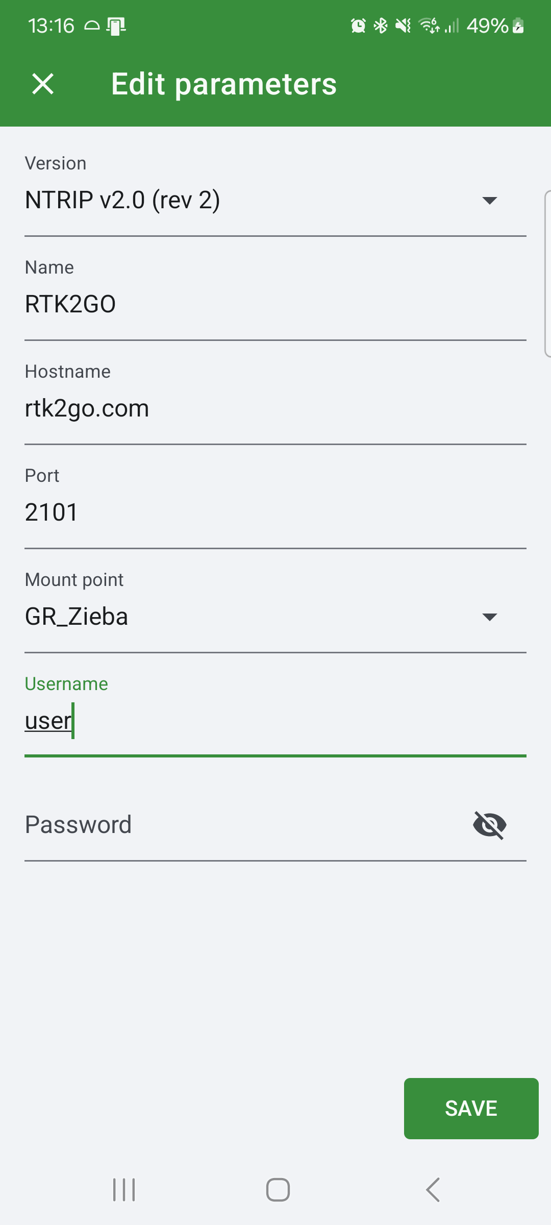
The integration of the NTRIP client into our LocusGIS application provides users with the ability to receive real-time GNSS corrections without the need to use other applications. It is essential to use a Bluetooth GNSS antenna that supports correction processing. Additionally, it is necessary to establish a connection to an NTRIP server (caster) that provides real-time corrections in your area. The application establishes a connection to the NTRIP server, downloads the corrections, and provides them to the GNSS antenna, which then obtains the refined data.
Precise application usage for your needs
With NTRIP client support, the LocusGIS application is the ideal tool for anyone who needs to work with high accuracy positional data. Such as surveying, precision mapping, agriculture, construction, etc.
Tolerance manager
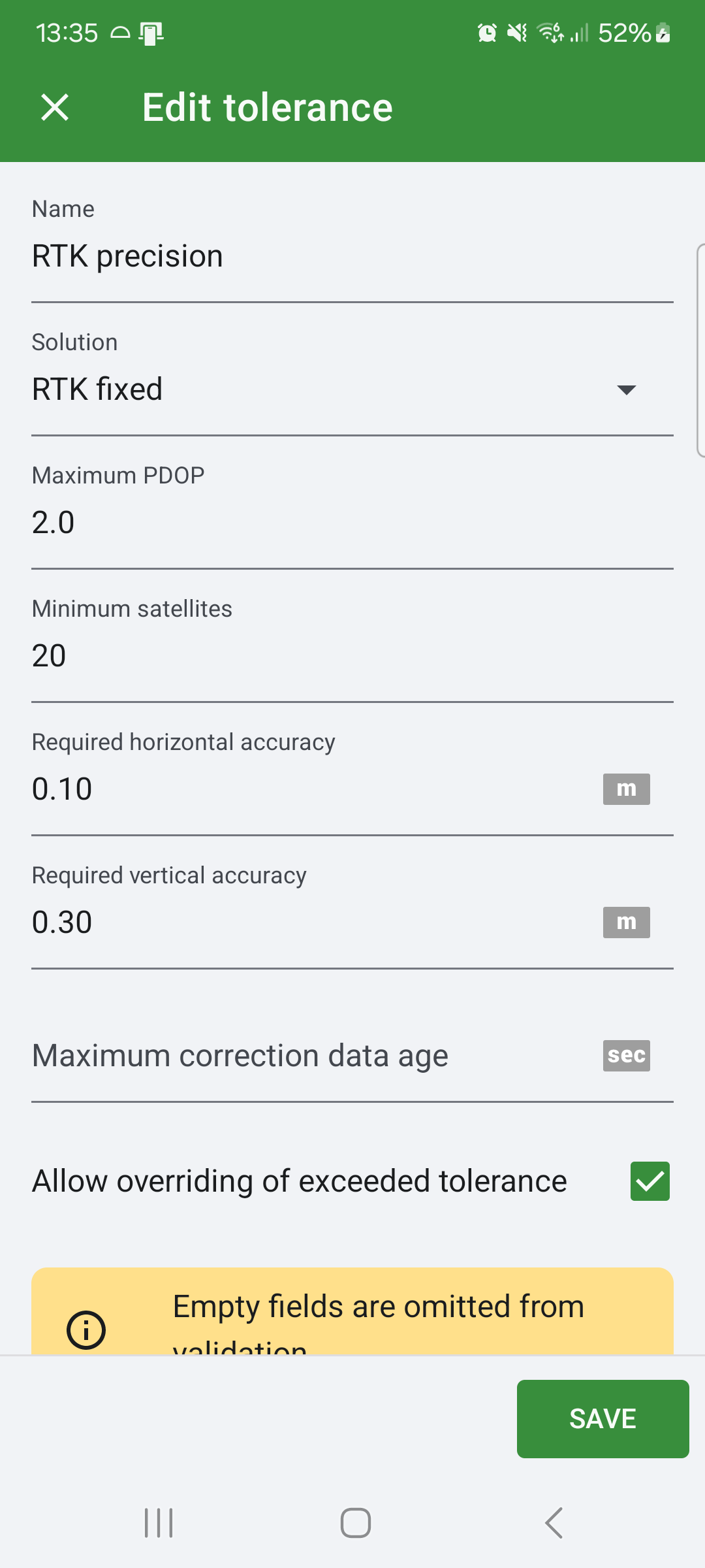
In addition to the NTRIP client, we have incorporated a new feature called Tolerance manager into the latest version. This feature enables users to specify the minimum required accuracy in position and height, the number of satellites used to obtain the position, the PDOP (Position Dilution of Precision) value, and the solution.
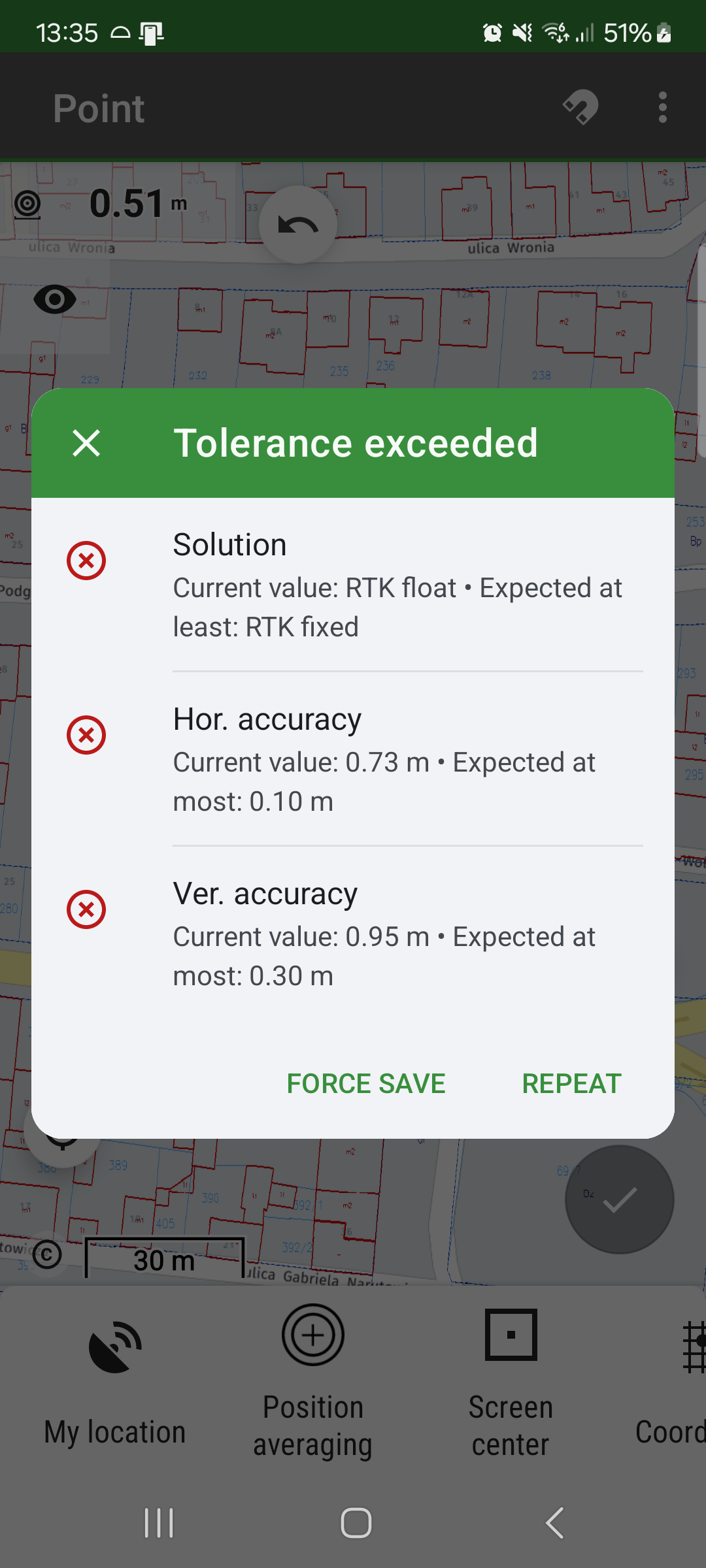
Upon saving a new point, the application verifies the set tolerances. If any of these tolerances are not met, the application displays a warning dialog to inform the user about the lack of accuracy. The user has the option of reacquiring the position or saving the point despite the lack of precision, should they wish to do so. This feature provides users with greater control and confidence in their data acquisition.
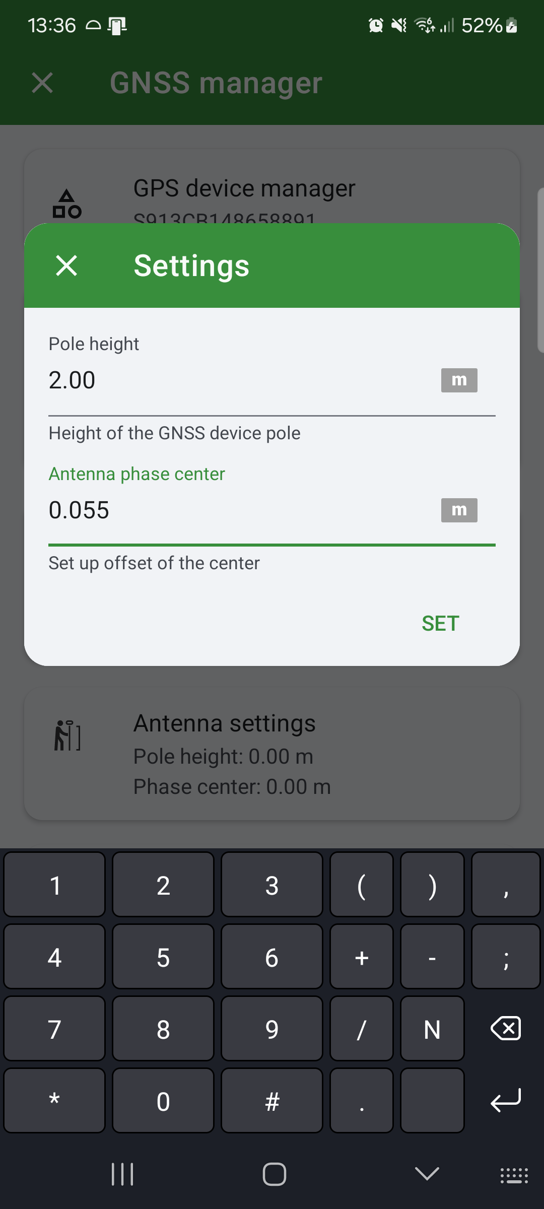
Adjusting the height of the pole and phase centre
When working with a precision GNSS antenna, it is of the utmost importance to ensure that the height of the pole is correct. This feature allows users to set the pole height and phase center, which is beneficial for those who require this functionality. The application automatically corrects the measured elevation based on these values.
We are confident that the Locus GIS 1.22, which includes a built-in NTRIP client and tolerance manager, will assist you in achieving greater accuracy and precision in your work, thereby enabling you to reach new heights in your performance goals and improve your overall work effectiveness.

Comments
4
Hi support, the ability to load a local Geo ID for compatibility with users working on local Geo ID (Machine control) etc. This is very much appreciated. Thanks in advance.
I’m sorry, but would you send us more information about Geo ID?
It would be nice to see the current state of the tolerance, e.g. change the color of the title bar if the tolerance requirements are not met. This woud help in stakeout
Thank you for the idea. We are preparing a new dashboard with the ability to display current accuracy and other information. We will also consider the possibility to inform if the tolerance is (not) met.